Keep in ‘Secure’ Touch
The key to maintaining a high level of security is fail-safe interoperable communications primarily comprised of voice services, such as wireless phones that are equipped with walkie-talkie capabilities.
But today’s mobile communications devices – whether wireless phones or BlackBerry handhelds – could provide these high-security, multi-agency operations with much more than just interoperable voice services. They are able to integrate GPS technology and support data applications that could give commanders better control over their resources and allow them to make well-informed deployment decisions. Advanced data solutions also can assist with tracking the location of individuals or specific subsets of individuals at a particular agency, authenticating credentials for admittance to events or monitoring shift changes, managing equipment inventory, and accessing numerous databases instantaneously from the field.
Communicating among separate groups
Consider the multi-agency coordination required during an event like the Presidential Inauguration. Representatives from a variety of agencies – federal, state, and local – worked from a central, multi-agency communications center (MACC) in the suburbs of Washington, D.C. About 100 commanders from the various agencies gathered at the center, where they coordinated the efforts of their staff and communicated with each other to maintain security during the ceremony and along the parade route. To get information from the event site in D.C., commanders in the MACC relied on field agents to contact them over the phone or via walkie-talkies.All of that incoming information could be very difficult to manage, since a single agency may have hundreds of agents in the field. Plus, from the command center, it is often difficult to know exactly where specific individuals are located at any given time, or to know where specific resources – such as fire trucks or ambulances – are located if a quick response is needed.
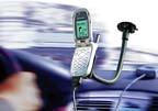
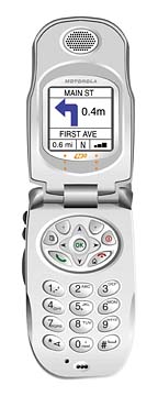
These concerns could be mitigated if officers in the field were using wireless phones or BlackBerry handhelds that are capable of providing GPS location and advanced data services. For example, the wireless devices could be tied to mapping software, allowing commanders to consult a giant screen in the MACC that visually identifies the location of each agency’s personnel by color-coded dots. Red dots could indicate fire personnel; blue dots police officers, and so on. Then, if there was an incident in which a certain response team was needed, commanders could instantly identify who was closest in order to minimize response times.
GPS also could be used to locate an individual from one of the agencies. Say there’s an agent who is accompanying a visiting dignitary, but because of unique circumstances, is unable to answer his radio or wireless phone. Using GPS signals from that agent’s phone and the mapping software, his position can be located and another agent – using his GPS phone to mark the agent’s coordinates – can be deployed to find him in the crowd.
Protecting the perimeter
Another way GPS could be used is to assist in ensuring the security of a perimeter or entrance where access is restricted. For example, an officer responsible for maintaining the security of an area would carry a GPS-enabled cell phone or BlackBerry handheld. The GPS would provide a history of the officer’s location, providing his or her commander with an assurance that the area of responsibility is appropriately secured.GPS also could be a valuable, timesaving tool in the event of a tragic incident where agencies must coordinate to collect evidence over a large geographical area. Take for example, the 2003 disaster in which the Space Shuttle Columbia disintegrated prior to landing and debris was scattered across Texas and Louisiana. In that case, the FBI, Federal Emergency Management Agency, the Federal Aviation Administration, military forces from Fort Hood, and state and local police authorities worked together to recover the thousands of pieces of the shuttle wreckage.
If every individual involved in the recovery effort had a wireless phone or BlackBerry equipped with GPS, the latitudinal and longitudinal coordinates of each piece of debris discovered could have been marked instantly and fed into a database that investigators then would use to determine the cause of the accident.
Wireless phones and BlackBerry handhelds also have other data capabilities that have been widely accepted in the commercial world, but could be easily deployed for public safety purposes.
For instance, barcode readers and Bluetooth-enabled barcode scanners that attach to wireless phones and Blackberry handhelds respectively could give law enforcement agencies scanning capabilities to monitor entry to secure areas. For example, at the G-8 Summit at Sea Island, Ga., only certain individuals were allowed onto the island. The agencies in charge of security could have employed a barcode reader to scan the credentials of those entering the island. And, once the credentials were scanned, the phone could receive a photo from a database to confirm that the person in possession of that badge has the right to enter. The database also could retain the information that the individual already has entered, in case the person’s location or entry status comes into question.
Role of barcodes
Barcode scanning also could be used to help commanders monitor shifts. In this scenario, all officers would be required to scan their credentials at the start of their shift, and then scan again if they take a break or leave for the day. This information would be captured in a database that would allow commanders to know how many officers are on duty at a given time and adjust schedules accordingly if necessary.Agencies could use barcode scanning to track equipment, such as fleet vehicles necessary for the event. For a large, one-time event, agencies need to bring many pieces of equipment with them. Barcode scanners could be used to record when the equipment left the warehouse, when it was loaded on and off a truck or airplane, and when it was logged on the event site.
Java-enabled wireless phones and BlackBerry handhelds could be utilized for access to internal address books and directories for convenient communications. Moreover, preset menus could be created, so if an individual officer on patrol needed a break or someone to deliver foul-weather gear, he could send that message with the push of a button, rather than tying up the radio voice channels.
The devices could also enable officers to wirelessly access investigative files or do database queries in the National Crime Information Center and other key databases from the field. And, because the devices have excellent graphics capabilities, agencies could retrieve photos of suspected criminals or receive this information as part of an all points bulletin in what would amount to an electronic “Wanted” poster.
While these enhanced data services that incorporate GPS and mapping software, or wireless barcode readers, may seem like they would be too complicated, expensive or time-consuming to deploy for one-time events, that is not the case.
Some wireless providers have been offering phones with GPS capabilities for several years, and as the industry has moved toward compliance with E911 regulations, all wireless phones manufactured since September 2004 incorporate GPS. Even BlackBerry handhelds, which are typically used for accessing e-mail, are now equipped with GPS.
With the addition of temporary cell sites and mobile satellite cellular trucks at these events, agencies can have redundant communications infrastructure and increase network capacity.
The combination of traditional voice and walkie-talkie functions with advanced data applications is critical.
Sidebar: Emergency Talk Without Power
What happens at special events or during crisis situation when commercial power goes down? Pittsburgh-based RemComm knows how to handle such situations. A technology company specializing in radio-based emergency communications and data transfer, it recently used a newly developed system to aid Hurricane Katrina recovery and relief efforts. RemComm was contracted by Centropy, Inc., a not-for-profit corporation that provides emergency communications systems in the event of disasters. The system enables security and emergency personnel to send/receive time-sensitive data by combining simple radios with laptop computers and interfacing equipment.Looking for a reprint of this article?
From high-res PDFs to custom plaques, order your copy today!