This website requires certain cookies to work and uses other cookies to help you have the best experience. By visiting this website, certain cookies have already been set, which you may delete and block. By closing this message or continuing to use our site, you agree to the use of cookies. Visit our updated privacy and cookie policy to learn more.
This Website Uses Cookies By closing this message or continuing to use our site, you agree to our cookie policy. Learn MoreThis website requires certain cookies to work and uses other cookies to help you have the best experience. By visiting this website, certain cookies have already been set, which you may delete and block. By closing this message or continuing to use our site, you agree to the use of cookies. Visit our updated privacy and cookie policy to learn more.
GIS Technology for Incident Command System
September 1, 2004
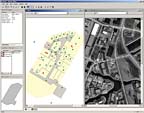
Kinetic Solutions, St. Louis, has introduced SCOUT – an acronym for "Special Crisis Operations for Urban Terrain" – the company’s incident command system. SCOUT is an advanced tactical response support system that integrates the use of aerial photography, digital floor plans of the building, wireless video, 360? immersive iPIX photography, and CAD-drawn vector overlays for each building.